To start with, it is an empty map, a map to be discovered by creation. Mostly materialised as a white wall, a white board, a panel, equipped with a neutral grid symbolising imaginative latitudes and longitudes, it is a map in the making. On it, a visionary landscape will evolve in a step-by-step process through collective interventions: First, by creating singular elements such as place names and descriptions; second, by relating them; third, by adding a visual geographic morphology and in a final step, paths that lead through the map.
The Foundland Map (FM) is a map
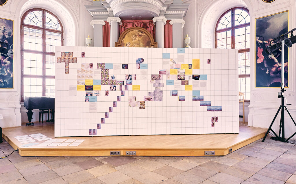
© Giovanni Ambrosio. Foundlnad Map, Entangled Matter, Fulda 2023
The Foundland Map (FM) is Creation instead of representation
Maps are not only representations of real material conditions but constructions of reality. They create a geography by presenting it. The circumstance, for instance, that Europe is generally situated in the centre of the world map is not given by geographical facts but due to a politically motivated decision. The Foundland Map therefore rediscovers the map as a creative space and adopts it for the purpose to actively invent spaces.
The Foundland Map (FM) is future exploration
The Foundland Map is a map of a not yet existing place. An important tool for bringing something non-existent into the world is the practice of name-giving: Places emerge through their names. Hence part of the process is to choose and locate place names on the map.
Another one is the description of these places: the reflexive process of the map creation will feed into an utopian description of places based on new connections between words, letters, things, people, natures and places in order to rearrange the relationships between people, natures and things. For truly new places to emerge, we need to allow completely new and different forms of co-existence.

© Giovanni Ambrosio. Foundlnad Map, Entangled Matter, Fulda 2023
The Foundland Map (FM) makes visible the invisibe
Maps are visual displays, yet the visibility ranges on the edge of invisibility. Maps zoom out of places and transform them into morphological structures that are supposed to represent landscapes but all they show is patterns of colours. In analogy to this, the production of the Foundland Map includes a process of framing, cutting, reducing and multiplying images in such a manner that it transforms figurative representation into abstract patterns. Through this process the images become something else, something we could not think of when looking at the image at first, and thus point at the threshold between the visible and the invisible.
The Foundland Map (FM) interweaves texts and visuals
The Foundlandmap consists of a juxtaposition of texts, visuals and relating paths. None of these elements stands alone. One layer of intervention interacts with the others and creates constellations that affect each other. They add another dimension to the single element and explore the gap between the different parts, the writing and the visuals.
The Foundland Map (FM) is collaborative
The Foundlandmap is a collaborative endeavour, not the vision of one person. No one can determine the final outcome. This means not only that one literally has to squeeze in one’s own position on the board but that each participant has to take a stand to what the other ones have created previously and relate one’s own contribution it. Thus one needs to study one’s environment and carefully choose how to position oneself in contrast to the others.